5.1.10. Borehole collar file format
GIFtools assumes that the borehole collar file is in either the XYZ or CSV file format. The file must have the at least the following information (but not necessarily these specific names or order):
Hole_ID: If the hole ID names require a space, then a CSV file should be used. These identifications can be numeric or characters (with no quotes), but should be consistent with the survey and property files.
Easting: East coordinate in metres (may be local coordinate system)
Northing: North coordinate in metres (may be local coordinate system)
Elevation: Elevation in metres (z+ up) of the collar
Length: Length of the borehole in metres
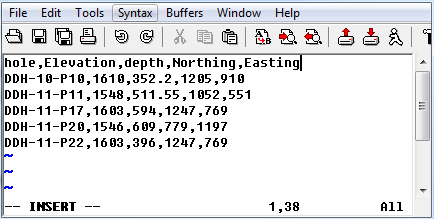
5.1.10.1. Example
Below is a sample collar file (CSV format) where “hole” is the Hole_ID and “depth” is the Length: